


This is a re-print of an article, reproduced by permission from the author, Mike Morffew from Tasmania Australia, but is relevant to all those interested in mapping issues:
I have been involved with orienteering mapping for around 45 years, while also working professionally as a cartographer in Tasmania. There have been many changes to orienteering mapping over that time. Mapping standards are more defined, and Sprint maps have been introduced. Better base material is often available (high resolution aerial imagery and LiDAR), GPS became available as an aid, and of course CAD, which has revolutionised the drawing process.
At a mapping workshop held in Hobart, July 2024, I emphasised the need to generalise map detail, knowing it had been a significant weakness in my own mapping for many years. As a mapper, I am occasionally asked by course planners whether some feature they noticed could or should be included on the map. Occasionally things are missed in the mapping process. Changes occur regularly, and it is important that the map is corrected in these instances. Competitors should have confidence that the map will be accurate and current. Occasionally however, I have generalised detail to produce a map that is both legible and designed for its purpose.
Who is the map being produced for?
Understanding that the map is meant to be produced for running competitors, not slowly moving course planners etc. is critical. The course planner and mapper experience the terrain and map in a vastly different manner to the fast-moving orienteer. The course planner mostly walks, frequently observes detail up close, when wanting to precisely position a control. In contrast, competent orienteers are moving quickly, fleetingly observing features from a distance. For the most part, using the terrain shape and prominent features only. Smaller details are barely noticed and only used at the control site, if necessary.
Obviously, when standing beside a feature, it will have a greater significance than when observed from further away. That difference is far more significant and more important than I had previously appreciated. Often, you only need to be a short distance (≈10m) away for small features to become insignificant, relative to the surrounding terrain. In recent years, this insight (feedback following national events, experiences interstate and overseas) and the obvious push from the IOF and OFA mapping committees has resulted in a change to my mapping approach.
Some Tasmanian terrain lacks the feature detail that is desirable to provide control site options and interesting, challenging orienteering. This often led to mapping small features and irrelevant detail to compensate.
The IOF Specification for Orienteering Maps (ISOM 2017-2) is the mapping guide which clearly outlines the standards and objectives that we should be working towards when producing forest orienteering maps. To be fully understood, a level of experience and explanation is required. Over the years, specifications have become increasingly prescriptive. This is aimed to raise standards and reduce commonly noted mapping problems. The need to generalise is a key point throughout the introduction.
Following (in italics), are extracts taken from the introduction.
Content
An orienteering map is a topographical map. It shall serve navigation through the terrain by representing a selection of prominent features, and it shall serve route choice by showing variations in runnability (impact on speed) and visibility. The map shall contain sufficient information for the competing
orienteer, while at the same time being legible at running speed and under varying weather and light conditions. This is accomplished by using a carefully designed set of symbols and colours and by emphasising generalisation.
The map shall only contain features which are obvious on the ground to a competitor at speed.
Producing a map is a process that involves a range of decisions such as selective generalisation, exaggeration, and distortion. Even the simplest maps are improved through these decisions.
Map reading
It is obvious that legibility is of utmost importance for orienteering maps.
Minimum graphical dimensions must be respected, and unnecessary detail must be avoided.
Generalisation and legibility
Good orienteering terrain contains a large number and a great variety of features. Those which are most essential for the competitor must be selected and presented on the orienteering map. To achieve this, in such a way that the map is legible and easy to interpret, generalisation must be employed.
It is impossible to fit everything in at scale, while maintaining legibility and fairness.
The IOF have very carefully designed symbols to standardise and meet the broad range of orienteering terrains across the world.
The forest map specifications (ISOM – 2017) are designed for symbols at a map scale of 1:15 000. Symbols must be enlarged proportionally where the maps are produced at larger scales such as 1:10 000 or 1:7500.
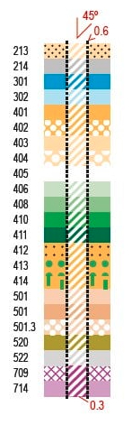
The following illustration demonstrates the real-world size (footprint) of some features below the symbol used at scale to represent them. 
As demonstrated in the above illustration, it frequently becomes impossible to fit everything in. Symbols are already at their minimum legible size if the map is drawn at the correct scale (as it should be). Reducing the symbol sizes to fit more detail renders the map almost illegible when printed at the correct scales and not to standard. We recently had instances where this has happened. The linework and symbols have been half their correct dimension, making the map difficult to read and unfair for competition.
Features that are smaller than the specifications may be mapped if they are distinct and obvious in the terrain, but they must be drawn and exaggerated, if necessary, to meet the minimum size.
The challenge for the mapper is what and how to map and to skilfully generalise, simplify, distort or exaggerate. The map may then be printed at a larger scale to allow for the reading / eyesight difficulty and the symbols and linework will be proportionally enlarged.
Basemap Revolution
In recent years, the availability of high-resolution aerial imagery (close to major urban centres) and often, LiDAR basemaps, has been revolutionary, making mapping a much easier task. It often provides the mapper a level of detailed information way beyond what is useful to the orienteer. The art of mapping is to convert that raw data into a map that shows the terrain and features as the orienteer experiences it. The orienteer is limited to what they see in the terrain at running pace while comparing it to the legible detail on the map, for navigation.
From the competitors’ point of view, a legible and accurate map is necessary for a qualified choice of route…….. However, skill in route choice and map reading loses all meaning if the map is not a good representation of the ground – if it is of poor legibility, inaccurate or out-of-date.
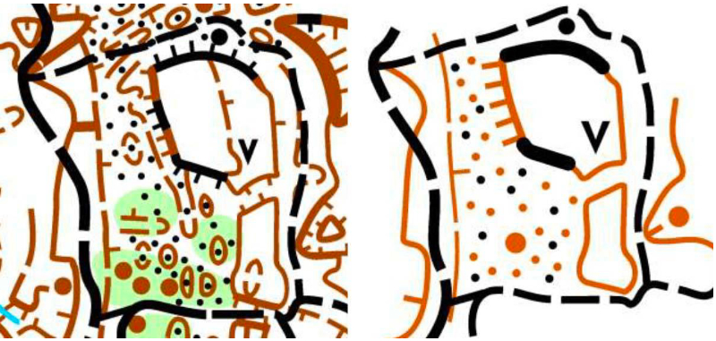
The following illustration is taken from a map review in Victoria by European mapping expert, Luděk Krtička. The image on the left is the original. The image on the right is the same area after simplification and generalisation. The character and relevant elements of the area have been maintained and the map is now legible.

Ground Shape
Ground shape is the most important feature and takes priority over other map elements. Orienteers often rely upon the relationship between contours and other map features for navigation. The mapper must ensure that contours represent the terrain shape. Contours, whether derived from LiDAR, photogrammetry, or any other source, often need adjusting by the mapper to provide a true picture of the terrain as the orienteer sees it.
The shape of the ground is the most important aspect of an orienteering map. The correct use of contours (including index contours) to show a three-dimensional picture of the ground shape and height difference cannot be overemphasised.
Sprint Maps
The Sprint map scale (1:4000) does allow for more detail to be shown. Generalisation, simplification, and exaggeration are still required for the map to highlight relevant information and be legible. A key difference between Forest (ISOM) and Sprint (ISSprOM) maps is the importance of ensuring that access routes and uncrossable features are clear to the orienteer for fair competition. Frequently, detail requires exaggeration or simplification so that decisions can be made by the competitor with confidence at competition speed. Point features and unnecessary details need to be kept to a minimum as they clutter the map and reduce legibility and clarity.
Course planners need to work closely with the mapper to ensure the map is fair for their courses. It cannot be taken for granted that the whole map, as initially mapped will be clear, legible, and fair. An example of this is gates – are they locked or unlocked during competition time.
To achieve fairness, it is necessary for mapmakers and course planners to collaborate more closely than for other disciplines.
I sometimes wonder whether the frequent use of sprint / urban / park maps creates an unrealistic expectation for some competitors when changing to orienteering in the forest. In the urban environment, the orienteer is mostly navigating by obvious elements such as buildings, sealed paths, and man-made features. It is rare to not know your precise position and you can always see obvious features such as buildings, fences and paths. Sprint orienteering is largely about rapid map reading and route choice decisions. In the forest however, features are often vague or open to interpretation (such as rock features, mined or eroded ground, vegetation) and abstract in nature (e.g. contours). The skills required for navigation and map reading are different. In the forest, you traverse across terrain with only an approximate idea as to your precise position. Reading the map and terrain is much more subjective and requires a different approach, given the variables of the forest and limitations of maps as discussed earlier.
School Maps
There can be a difficulty where maps made for schools are used for orienteering competitions as the two users have different requirements. School maps are made for teaching beginner map reading and spatial thinking. The scale is usually at least 2x larger than sprint maps. Smaller features may be mapped and less generalisation is necessary. Sometimes, features are drawn in a more illustrative style than symbolic, as required for orienteering.
Sprint maps are made for users with a higher level of map reading skill and experience, with a better understanding of the various unique symbols e.g. Out of Bounds being used for both garden areas and private / uncrossable zones.
********
A leading mapper said to me the best map enables the orienteer to run at the highest pace. Meaning the map matches what the quickly moving orienteer would likely observe.
I read a mappers blog where he wrote “Whenever I find myself saying this would be a nice control site, I know I am over mapping.”
Over recent years, I have been trying to improve my existing maps in the areas outlined when making updates and striving to apply this approach to new maps. For the most part, the changes are subtle, and most orienteers would not even notice. There is no doubt however, it leads to clearer and fairer maps for the competitor.
by Mike Morffew, 25 February 2025









 Facebook
 Twitter
 Instagram
 YouTube
